42/59
)
)
)
)

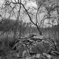
Where the koʻa used to stand, according to McAllister. He comments that it was destroyed when the present road was built, and that one was never supposed to walk behind it. In the image is the WWII fortification that stands at the point where McAllisterʻs vague map places the fishing shrine.
- Dimensions
- 1000*779
- Visits
- 2390