
") Kupalaha or Kupalahaʻa
Kupalaha or Kupalahaʻa
2379 hits near Kupalahaʻa (2313 visits) This series of loʻi lies along a stream, still running.") Loʻi (wetland taro terraces) near Kupalahaʻa
Loʻi (wetland taro terraces) near Kupalahaʻa
2313 hits
This series of loʻi lies along a stream, still running. The north end of a platform heiau in a large complex of sites. The heiau faces south, overlooking th...") Coastal heiau, 2010
Coastal heiau, 2010
2472 hits
The north end of a platform heiau in a large complex of sites. The heiau faces south, overlooking the Kona coast and Mauna Loa. A habitation complex near Lapakahi") Nuʻuanu, 2010
Nuʻuanu, 2010
2416 hits
A habitation complex near Lapakahi A unique path lined with upright stones. This section is cleared, but the path extends into the brus...") Area 1753 - ala
Area 1753 - ala
2436 hits
A unique path lined with upright stones. This section is cleared, but the path extends into the brush for another 300 yards. Its purpose remains uncertain, although it appears ceremonial.") ʻAlauiki fishing shrine, 1995
ʻAlauiki fishing shrine, 1995
214 hits") Kahua, 2010
Kahua, 2010
2379 hits") Pōhakuloa, 2010
Pōhakuloa, 2010
1975 hits The wall in the foreground is part of an enclosure that may have been constructed in historic times ...") Ahuaʻumi, 2004
Ahuaʻumi, 2004
14056 hits
The wall in the foreground is part of an enclosure that may have been constructed in historic times to hold animals Graves at Lekeke battlefield, Kuamʻo") Lekeke, 2010
Lekeke, 2010
20015 hits
Graves at Lekeke battlefield, Kuamʻo A possible ceremonial platform adjacent to the ocean.") Kakapa Bay, 2010
Kakapa Bay, 2010
14998 hits
A possible ceremonial platform adjacent to the ocean. A coastal enclosure with an unusual bowl-shaped stone") Pōhakuloa, 2010
Pōhakuloa, 2010
2413 hits
A coastal enclosure with an unusual bowl-shaped stone Near the pā of Kalaniopuʻu") Hōkūliʻa 16756, 2010
Hōkūliʻa 16756, 2010
878 hits
Near the pā of Kalaniopuʻu Old Government Road, built in the 19th century, runs straight through a large platform heiau.") Hōkūliʻa 16384, 2010
Hōkūliʻa 16384, 2010
906 hits
Old Government Road, built in the 19th century, runs straight through a large platform heiau.") Hōkūliʻa 16457, 2010
Hōkūliʻa 16457, 2010
15544 hits Near salt pans at the beach. A kiʻi depicting a waʻa (canoe) - perhaps with the sun above.") Kaūpūllehu kiʻi pōhaku, 2010
Kaūpūllehu kiʻi pōhaku, 2010
20100 hits
Near salt pans at the beach. A kiʻi depicting a waʻa (canoe) - perhaps with the sun above. One of the main platforms of Kūpopolo after the heiau was cleared.") Kūpopolo2, 2010
Kūpopolo2, 2010
2161 hits
One of the main platforms of Kūpopolo after the heiau was cleared.") Kahua, 2010
Kahua, 2010
2433 hits Note the use of upright slabs in the wall construction. This area contained numerous sites but may h...") Near the old base commissary - wall section
Near the old base commissary - wall section
1969 hits
Note the use of upright slabs in the wall construction. This area contained numerous sites but may have been bulldozed by a company leasing the land from DHHL. Around 2014, a large kiawe tree fell on this enclosure, damaging it. Note the opening in the side of...") Area 1752 - heiau
Area 1752 - heiau
2166 hits
Around 2014, a large kiawe tree fell on this enclosure, damaging it. Note the opening in the side of the small platform. The original archaeological team that identified this heiau dismantled the structure and then rebuilt it somewhat shorter, without the empty space in its center. The space may have had a ceremonial function. A small ahu mauka of the heiau enclosure") Area 1752 - small platform or ahu
Area 1752 - small platform or ahu
1978 hits
A small ahu mauka of the heiau enclosure The exterior of the thick, low wall that forms the principal enclosure at the heiau.") Area 1752 - heiau
Area 1752 - heiau
1923 hits
The exterior of the thick, low wall that forms the principal enclosure at the heiau.") Area 1755 - small heiau
Area 1755 - small heiau
2056 hits Possibly a habitation site. Note the use of upright slabs in the wall.") Area 1753 - enclosure
Area 1753 - enclosure
2275 hits
Possibly a habitation site. Note the use of upright slabs in the wall. This site is possibly a small heiau - note the prominent upright triangular slabs and the fact that ...") Area 1755 - small heiau or ahu
Area 1755 - small heiau or ahu
2129 hits
This site is possibly a small heiau - note the prominent upright triangular slabs and the fact that the enclosure has no opening. Identified as feature K on a tag left at the site") Area 1736 - small platform
Area 1736 - small platform
1843 hits
Identified as feature K on a tag left at the site Note the prominent upright slab on one side.") Area 1736 - small platform
Area 1736 - small platform
2016 hits
Note the prominent upright slab on one side. Possibly a house site.") Area 1745 - a large enclosure
Area 1745 - a large enclosure
2148 hits
Possibly a house site. The remnant of the platform at Hawea heiau, with construction and dredging debris pushed up against ...") Hawea, 1994
Hawea, 1994
2123 hits
The remnant of the platform at Hawea heiau, with construction and dredging debris pushed up against it from the creation of the marina at Hawaiʻi Kai by Kaiser Development Corp. Note the lined pit in the foreground. A wall or alignment far up of the side of a slope at or near Hawea Heiau.") Hawea 1, 2000
Hawea 1, 2000
1856 hits
A wall or alignment far up of the side of a slope at or near Hawea Heiau.") Area 1736 - walled enclosure
Area 1736 - walled enclosure
2100 hits Note the two large slabs lying together in front of the upright - perhaps a suggestion of a kohe (va...") Area 1736 - upright and ahu
Area 1736 - upright and ahu
2074 hits
Note the two large slabs lying together in front of the upright - perhaps a suggestion of a kohe (vagaina) in connection with the ule (penis, upright). Such male / female (Wakea / Papa, Kū / Hina) pairings are not uncommon - as seen at the heiau in area 1752 a little distance to the west of this complex. Possibly a water source, access to the underground streams that once flowed through the porous limes...") Makai of revetments - a walled sinkhole
Makai of revetments - a walled sinkhole
2442 hits
Possibly a water source, access to the underground streams that once flowed through the porous limestone from the distant mountains to the sea. US Navy archaeologists maintain that these were not Hawaiian pre-contact structures. They were bulld...") Area 1746 - damaged platform
Area 1746 - damaged platform
1914 hits
US Navy archaeologists maintain that these were not Hawaiian pre-contact structures. They were bulldozed to clear lead shotgun pellets from an area used as a trap and skeet shooting range - even though they lay at the far periphery, and even though the area was designated as one of the very last preserves for the endangered Oʻahu akoko plant. In this image a damaged platform lies adjacent to an intact platform - shown in another image in this album. The heiau at ʻAwawamalu, destroyed in the 1946 tidal wave. Its outline can be seen in the water, in...") Wawamalu, 2009
Wawamalu, 2009
2023 hits
The heiau at ʻAwawamalu, destroyed in the 1946 tidal wave. Its outline can be seen in the water, in the inlet that was probably the ancient canoe landing spot.") Hōkūliʻa 16742, 2009
Hōkūliʻa 16742, 2009
17895 hits A wall near the pā of Kalaniopuʻu") Hōkūliʻa 16754, 2009
Hōkūliʻa 16754, 2009
917 hits
A wall near the pā of Kalaniopuʻu The pā (house enclosure) of the aliʻi nui Kalaniopuʻu.") Hōkūliʻa 16756, 2009
Hōkūliʻa 16756, 2009
883 hits
The pā (house enclosure) of the aliʻi nui Kalaniopuʻu.") Hōkūliʻa Halekiʻi, 2009
Hōkūliʻa Halekiʻi, 2009
931 hits") Hōkūliʻa Halekiʻi, 2009
Hōkūliʻa Halekiʻi, 2009
912 hits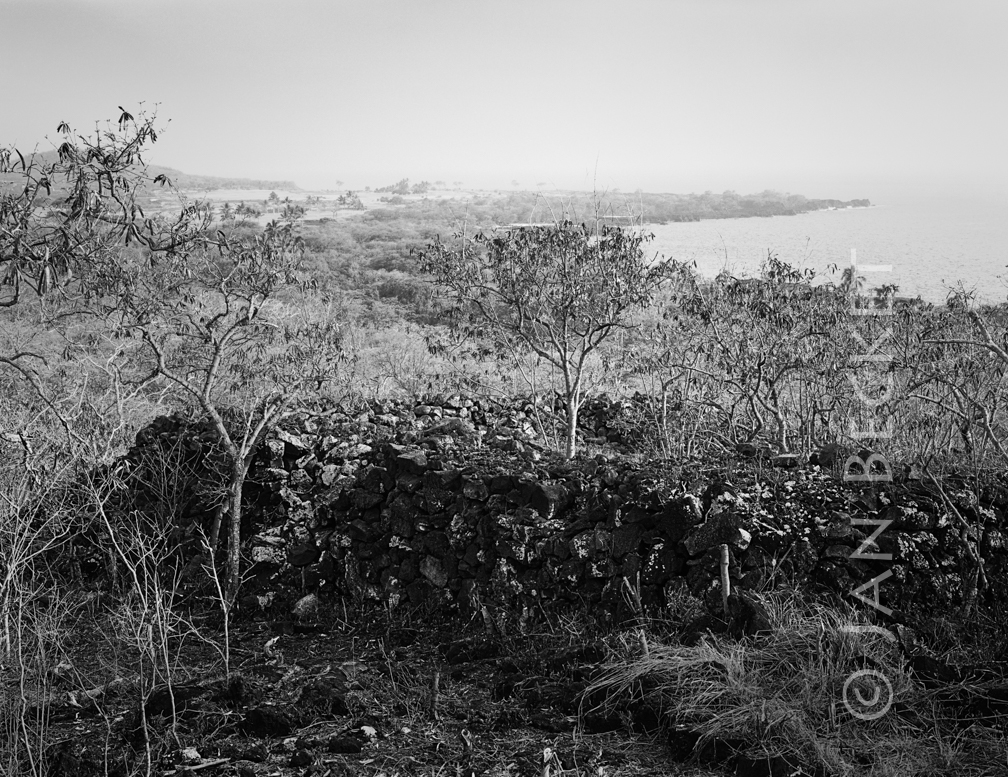 Ukanipō Heiau, 2009
1159 hits
The principal structure at Ukanipō, a complex of many other features covering a large area. Ukanipō is also the name of a heiau in Mākua Valley on Oʻahu.") Kapuanoni, 2009
Kapuanoni, 2009
1240 hits A heiau for training in lua.") Kaneheilani Heiau, 2009
Kaneheilani Heiau, 2009
22922 hits
A heiau for training in lua. A linear heiau structure in ʻAimakapā loko iʻa (fishpond). Sand dunes at the makai side of the po...") ʻĀimakapā, 2009
ʻĀimakapā, 2009
15830 hits
A linear heiau structure in ʻAimakapā loko iʻa (fishpond). Sand dunes at the makai side of the pond needed to be opened in order to fill it with water. An upright stone in the surf, said to be a boundary marker.") Kaloko, 2009
Kaloko, 2009
1172 hits
An upright stone in the surf, said to be a boundary marker. The pōhaku kiʻi (petroglyph) of Kawāwāmalu at Keʻekū. Kawāwāmalu was an invading chief from ...") Keʻekū, Kawawamalu, 2009
Keʻekū, Kawawamalu, 2009
23784 hits
The pōhaku kiʻi (petroglyph) of Kawāwāmalu at Keʻekū. Kawāwāmalu was an invading chief from Maui Island who was defeated and sacrificed at Keʻekū. Note that his head falls into a large crack in the stone. The pōhaku kiʻi (petroglyph) with the head falling into the water is said to depict the invading a...") Keʻekū, Kawāwāmalu, 2009
Keʻekū, Kawāwāmalu, 2009
12501 hits
The pōhaku kiʻi (petroglyph) with the head falling into the water is said to depict the invading aliʻi Kawāwāmalu who was killed and then offered as a mōhai (sacrificial offering) at Keʻeku.") Enclosure and upright, 2009
Enclosure and upright, 2009
2642 hits This small structure looks to the south, to the Kona coast, Mauna Loa and Hualalai.") Small disturbed platform, 2009
Small disturbed platform, 2009
2466 hits
This small structure looks to the south, to the Kona coast, Mauna Loa and Hualalai.