
 Planting ʻakiʻaki grass to control beach erosion at Hanakanaia Bay") Kanu kahakai, 2015
Kanu kahakai, 2015
2175 hits
Planting ʻakiʻaki grass to control beach erosion at Hanakanaia Bay") 05 11 Halawa mauka-1
05 11 Halawa mauka-1
1815 hits") 06 4 Halawa 85 plat
06 4 Halawa 85 plat
1809 hits Planting ʻakiʻaki grass to control beach erosion at Hanakanaia Bay") Kanu kahakai, 2015
Kanu kahakai, 2015
2061 hits
Planting ʻakiʻaki grass to control beach erosion at Hanakanaia Bay") 15 12 Kanu9
15 12 Kanu9
1960 hits (2088 visits) Volunteers work to clear the Ala Loa. The project was begun by the PKO to create a path that circles...") Ala Loa (Long Path)
Ala Loa (Long Path)
2088 hits
Volunteers work to clear the Ala Loa. The project was begun by the PKO to create a path that circles the island, to be used for traditional protocol during the yearly Makahiki. As part of the traditional protocol, the god Lono is carried in procession entirely around an island. (2014 visits) Volunteers work to clear the Ala Loa. The project was begun by the PKO to create a path that circles...") Ala Loa (Long Path)
Ala Loa (Long Path)
2014 hits
Volunteers work to clear the Ala Loa. The project was begun by the PKO to create a path that circles the island, to be used for traditional protocol during the yearly Makahiki. As part of the traditional protocol, the god Lono is carried in procession entirely around an island. (1996 visits) Volunteers work to clear the Ala Loa. The project was begun by the PKO to create a path that circles...") Ala Loa (Long Path)
Ala Loa (Long Path)
1996 hits
Volunteers work to clear the Ala Loa. The project was begun by the PKO to create a path that circles the island, to be used for traditional protocol during the yearly Makahiki. As part of the traditional protocol, the god Lono is carried in procession entirely around an island.") 16 4 AlaLoa-12
16 4 AlaLoa-12
1925 hits (1899 visits)") Ala Loa (Long Path)
Ala Loa (Long Path)
1899 hits This is a modern structure intended to serve as a teaching center for navigators. It was built under...") Heiau at Kealaikahiki
Heiau at Kealaikahiki
2075 hits
This is a modern structure intended to serve as a teaching center for navigators. It was built under the direction of Mau Pilug, the navigator credited with reviving traditional Polynesian navigation. Moaʻula Iki - sunrise - after the protocol") Moaʻula Iki - sunrise, 2016
Moaʻula Iki - sunrise, 2016
1998 hits
Moaʻula Iki - sunrise - after the protocol") 16 3 Kanu-1
16 3 Kanu-1
1849 hits Just after the chanting of E Ala E, when the sun has risen and the protocol had ended - taken with t...") Moaʻula Iki - sunrise - after the protocol, 2016
Moaʻula Iki - sunrise - after the protocol, 2016
1839 hits
Just after the chanting of E Ala E, when the sun has risen and the protocol had ended - taken with the permission of the chanters, of course.") 16 3 Kanu-2
16 3 Kanu-2
1925 hits Between the stakes lies the section cleared of UXO (unexploded ordnance) down to a depth of four fee...") UXO markers, Kahoʻolawe, 2016
UXO markers, Kahoʻolawe, 2016
2442 hits
Between the stakes lies the section cleared of UXO (unexploded ordnance) down to a depth of four feet. Outside the markers, the terrain has only been surface (visually) cleared. Other sections of the island in more inaccessible terrain have never been cleared and are off limits. This prominent upright lies close to the platform shown in another image in this album. The upright ...") Upright pōhaku, Hanakanaia, 2016
Upright pōhaku, Hanakanaia, 2016
1772 hits
This prominent upright lies close to the platform shown in another image in this album. The upright forms a potentially intriguing alignment with the large stone at the nearby ahu. Highly endangered ʻilioholoikauaua (Monk Seals) sometimes rest on the beach. This prominent upright lies close to the platform shown in another image in this album. The upright ...") Upright pōhaku, Hanakanaia, 2016
Upright pōhaku, Hanakanaia, 2016
1889 hits
This prominent upright lies close to the platform shown in another image in this album. The upright forms a potentially intriguing alignment with the large stone at the nearby ahu. The post warns of the limit of clearance for sub-surface UXO (unexploded ordnance). This platform lies next to a large pōhaku with a deep cavity at its base. Branch coral makes up a p...") Large Ahu, Hanakanaia, 2016
Large Ahu, Hanakanaia, 2016
1893 hits
This platform lies next to a large pōhaku with a deep cavity at its base. Branch coral makes up a part of its structure, and a prominent upright stone stands nearby, next to the sandy beach. Members of a well-known Hawaiian family identify this structure as connected with Kanaloa. (2021 visits) Volunteers work to clear the Ala Loa. The project was begun by the PKO to create a path that circles...") Ala Loa (Long Path)
Ala Loa (Long Path)
2021 hits
Volunteers work to clear the Ala Loa. The project was begun by the PKO to create a path that circles the island, to be used for traditional protocol during the yearly Makahiki. As part of the traditional protocol, the god Lono is carried in procession entirely around an island. All replanting in the upland region must be done above ground because of the danger of UXO (unexplod...") Irrigated planting beds on the hardpan
Irrigated planting beds on the hardpan
1849 hits
All replanting in the upland region must be done above ground because of the danger of UXO (unexploded ordnance) just below the surface. Haleakalā and Maui are in the distance.") 95 4 Halawa 2010-3
95 4 Halawa 2010-3
1611 hits") 95 4 Halawa75 Pohaku
95 4 Halawa75 Pohaku
1646 hits") 95 4 Halawa85 encl1a
95 4 Halawa85 encl1a
1605 hits Before the heiau was cleared. McAllister made the comment in his 1933 survey that Maunawila was mark...") Maunawila Heiau
Maunawila Heiau
1807 hits
Before the heiau was cleared. McAllister made the comment in his 1933 survey that Maunawila was marked by a large number of randomly-placed large boulders. A group of large pōhaku at the edge of a ledge at the ocean at Pūpūkea. Interestingly, a gulch di...") Nā Ukali a Pele - Peleʻs Followers
Nā Ukali a Pele - Peleʻs Followers
1952 hits
A group of large pōhaku at the edge of a ledge at the ocean at Pūpūkea. Interestingly, a gulch directly mauka is also named after Pele: Kalahopele (Peleʻs scrotum). Danny Camplin was a surfer who drowned at Waimea in 1994. His friends and/or family made the unfortu...") Kalakū
Kalakū
1814 hits
Danny Camplin was a surfer who drowned at Waimea in 1994. His friends and/or family made the unfortunate decision to cement a memorial plaque onto Kalakū — probably ignorant of its cultural significance. A large, unrecorded structure mauka of the road, at the foot of the pali. It is made up of an inclin...") Kaʻaʻawa 2a, 2006
Kaʻaʻawa 2a, 2006
1871 hits
A large, unrecorded structure mauka of the road, at the foot of the pali. It is made up of an incline, terraced and paved in areas with ʻili ʻili, and a large C-shaped structure on the north side. This may be a heiau or the residence of a person with some rank and status. A large, unrecorded structure mauka of the road, at the foot of the pali. It is made up of an inclin...") Kaʻaʻawa 2b, 2006
Kaʻaʻawa 2b, 2006
1664 hits
A large, unrecorded structure mauka of the road, at the foot of the pali. It is made up of an incline, terraced and paved in areas with ʻili ʻili, and a large C-shaped structure on the north side. This may be a heiau or the residence of a person with some rank and status. Joseph Kekona was the last traditional keeper of Huilua loko iʻa (fishpond) in the 1940s. In this p...") Huilua loko iʻa, Joe Kekona, Kahana Bay, 1998
Huilua loko iʻa, Joe Kekona, Kahana Bay, 1998
2066 hits
Joseph Kekona was the last traditional keeper of Huilua loko iʻa (fishpond) in the 1940s. In this photo he is in his 90s, but still full of stories of the pond, a place for mullet.") Hauʻula Stream enclosure1, 2000
Hauʻula Stream enclosure1, 2000
1740 hits The same enclosure as in a 2006 image. A large, unrecorded structure mauka of the road, at the foot ...") Kaʻaʻawa 2, 2017
Kaʻaʻawa 2, 2017
1737 hits
The same enclosure as in a 2006 image. A large, unrecorded structure mauka of the road, at the foot of the pali. It is made up of an incline, terraced and paved in areas with ʻili ʻili, and a large C-shaped structure on the north side. This may be a heiau or the residence of a person with some rank and status. A substantial platform heiau, with evidence of occasional ceremonial visits - kava root in 2006 and ...") Kaʻaʻawa 1, 2017
Kaʻaʻawa 1, 2017
1717 hits
A substantial platform heiau, with evidence of occasional ceremonial visits - kava root in 2006 and a large wooden bowl in 2017.") 15 10 Na Ukali O Pele Pupukea
15 10 Na Ukali O Pele Pupukea
1766 hits Rudy Mitchel commented numerous times that Puʻuomahuka might not be the name of this heiau, but jus...") Puʻuomahuka 3, 2015
Puʻuomahuka 3, 2015
1602 hits
Rudy Mitchel commented numerous times that Puʻuomahuka might not be the name of this heiau, but just the area where it stands. He felt that Hawaiians in the l930s were protective of heiau names and locations and did not always share accurate or complete information with McAllister. The striking upright pōhaku remaining at Hanawao. Althought McAllister uses the name \"Hanawao,\" the...") Hanawao, 2017
Hanawao, 2017
1690 hits
The striking upright pōhaku remaining at Hanawao. Althought McAllister uses the name "Hanawao," the family that cares for its graves at the heiau suggests the name "Kanawao," which has four possible translations in Nā Puke Wehewehe. "Hanawao" has no suggested translations. A lower corner of Hanawao / Kanawao. This is the most intact part of the heiau. Althought McAllister...") Hanawao, 2017
Hanawao, 2017
1660 hits
A lower corner of Hanawao / Kanawao. This is the most intact part of the heiau. Althought McAllister uses the name "Hanawao," the family that cares for its graves at the heiau suggests the name "Kanawao," which has four possible translations in Nā Puke Wehewehe. "Hanawao" has no suggested translations. A possible location for Kaumakaʻulaʻula is the point in the distance, based on McAllisterʻs descr...") 17-2 Kaumakaʻulaʻula
17-2 Kaumakaʻulaʻula
1687 hits
A possible location for Kaumakaʻulaʻula is the point in the distance, based on McAllisterʻs description of the heiau. The largest remaining heiau in Koʻolauloa, mostly intact.") Site 296
Site 296
1607 hits
The largest remaining heiau in Koʻolauloa, mostly intact. The largest remaining heiau in Koʻolauloa, mostly intact.") Site 296
Site 296
1621 hits
The largest remaining heiau in Koʻolauloa, mostly intact.") 95-1 Kawaewae 1
95-1 Kawaewae 1
1535 hits") 95-1 Kawaewae 2
95-1 Kawaewae 2
1578 hits") 95-1 Kawaewae 4
95-1 Kawaewae 4
1723 hits") 17 4 Nr Kawaʻewaʻe1 6910
17 4 Nr Kawaʻewaʻe1 6910
1275 hits") 17 4 N.Halawa 2010
17 4 N.Halawa 2010
1307 hits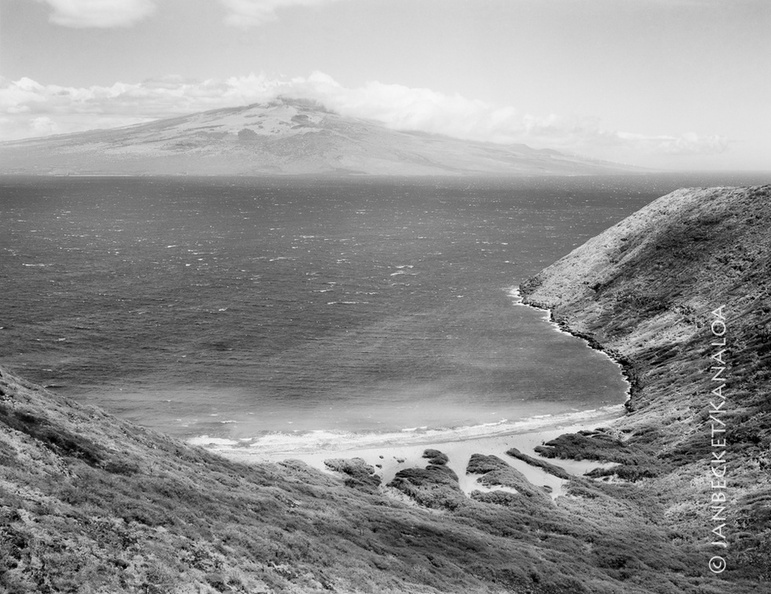 Kanapou Bay, 2017
1603 hits
Kanapou Bay faces Maui, across the Alalakeiki Channel. In Kanapou is the lua (pit, home) of the manō (shark) Kamōhoaliʻi, brother of Pele. A stone on the ahu at the summit of Moaʻula Nui, above, honors Kamōhoaliʻi. The lele at Moaʻula Iki. In the distance lies the island of Lānaʻi.") 17-9 MoaulaIki
17-9 MoaulaIki
1389 hits
The lele at Moaʻula Iki. In the distance lies the island of Lānaʻi. The ahu (stone altar) at Moa’ula Nui, a modern structure with double upright stones, to honor both...") 17-9 MoaulaNui
17-9 MoaulaNui
1498 hits
The ahu (stone altar) at Moa’ula Nui, a modern structure with double upright stones, to honor both the Nāulu rains and Kamōhoali’i, whose house lies below in Kanapou Bay.") 17-9 Kanu3
17-9 Kanu3
1546 hits") 17-9 Kanu1
17-9 Kanu1
1298 hits