Choose filters
Cancel
Validate
Choose filters
Validate
Validate
Validate

 Perhaps related to this or nearby structures: \" ... Thus 'Ai'ai performed his good work in establish...") Hakioawa - Heiau, 2012
Hakioawa - Heiau, 2012
3156 hits
Perhaps related to this or nearby structures: " ... Thus 'Ai'ai performed his good work in establishing kū'ula and ko'a all around the island of Maui. He is also said to have visited Kaho'olawe and established a kū'ula at Hakioawa ... though it differs from the others in being built on a high bluff overlooking the sea, somewhat like a temple; its stones are in the form of a square, with a space in the middle where the fishermen of Kaho'olawe laid their first fish caught ... 'Awa and kapa were also placed there as offerings to the fishing 'aumakua." - from a translated mo'olelo in Hawaiian Fishing Legends, ed by Dennis Kawaharada, p. 19. The naulu rain clouds approach from Haleakalā. Because the island sits in the leeward rain shadow o...") Hakioawa - Pōhaku near kūʻula, 2012
Hakioawa - Pōhaku near kūʻula, 2012
2955 hits
The naulu rain clouds approach from Haleakalā. Because the island sits in the leeward rain shadow of Haleakalā, the naulu rain has a great deal of cultural significance on Kahoʻolawe. 1994 (3067 visits) On the east side of Hakioawa") Hakioawa - Kūʻula kai (fishing shrine) 1994
Hakioawa - Kūʻula kai (fishing shrine) 1994
3067 hits
On the east side of Hakioawa") 94 KuʻulaKai3
94 KuʻulaKai3
2925 hits A kūʻula at Hakioawa, on the east bluff overlooking the bay") Hakioawa - Kūʻula kai, 1994
Hakioawa - Kūʻula kai, 1994
3129 hits
A kūʻula at Hakioawa, on the east bluff overlooking the bay Prominent pohaku near the ku'ula (fishing shrine) on the east bluff overlooking Hakioawa") Hakioawa - Pōhaku near kūʻula kai, fishing shrine, 2012
Hakioawa - Pōhaku near kūʻula kai, fishing shrine, 2012
3077 hits
Prominent pohaku near the ku'ula (fishing shrine) on the east bluff overlooking Hakioawa A modern structure on the west side of Hakioawa - where awa ceremonies take place and where visitors...") Hakioawa - Kahua Lele, 2012
Hakioawa - Kahua Lele, 2012
3303 hits
A modern structure on the west side of Hakioawa - where awa ceremonies take place and where visitors chant at the rising of the sun. A structure marking the navigation pathway to Kahiki (foreign lands) at Kealaikahiki.") Heiau at Lae Kealaikahiki, 2015
Heiau at Lae Kealaikahiki, 2015
3361 hits
A structure marking the navigation pathway to Kahiki (foreign lands) at Kealaikahiki. Its name translates as \"the path to far lands.\" The traditional departure place for voyages to the s...") Lae Kealaikahiki, 2015
Lae Kealaikahiki, 2015
3727 hits
Its name translates as "the path to far lands." The traditional departure place for voyages to the south. Modern sailors confirm that winds and currents make this an ideal point of departure, cutting the transit time as much as 10 days. According to some accounts, the prominent line of pōhaku that used to extend out into the sea were used as target practice and destroyed by the US Navy. Four large pōhaku mark the cardinal points of the compass at Lae Kealaikahiki.") Lae Kealaikahiki, 2015
Lae Kealaikahiki, 2015
3340 hits
Four large pōhaku mark the cardinal points of the compass at Lae Kealaikahiki. A small upright and ahu lies to the left of the trail as one ascents Moaʻula Iki") Upright, Moaʻula Iki. 2015
Upright, Moaʻula Iki. 2015
2665 hits
A small upright and ahu lies to the left of the trail as one ascents Moaʻula Iki at Moaʻula Iki, 2015 (2640 visits) The lele (altar) at Moaʻula Iki.") The lele (altar) at Moaʻula Iki, 2015
The lele (altar) at Moaʻula Iki, 2015
2640 hits
The lele (altar) at Moaʻula Iki. A double upright (rare) at the adz quarry") Puʻu Moiwi adz quarry, 1994
Puʻu Moiwi adz quarry, 1994
3277 hits
A double upright (rare) at the adz quarry The double upright (rare) at the adz quarry") Puʻu Moiwi adz quarry, 1994
Puʻu Moiwi adz quarry, 1994
3394 hits
The double upright (rare) at the adz quarry This lies along the trail to the summit, on the right as one ascends. A very large, very flat pōhak...") Double upright, Moaʻula Iki, 2015
Double upright, Moaʻula Iki, 2015
2171 hits
This lies along the trail to the summit, on the right as one ascends. A very large, very flat pōhaku lies just below, out of sight. Small stone ʻiliʻili fills the gap between the two uprights. It is possible that there is a deliberate astronomical alignment created by the two uprights. Its name translates as \"the path to far lands.\" The traditional departure place for voyages to the s...") Lae Kealaikahiki, 2015
Lae Kealaikahiki, 2015
2184 hits
Its name translates as "the path to far lands." The traditional departure place for voyages to the south. Modern sailors confirm that winds and currents make this an ideal place for departure. According to some accounts, the prominent line of pōhaku that used to extend out into the sea were used as target practice and destroyed by the US Navy. This is a modern structure intended to serve as a teaching center for navigators. It was built under...") Heiau at Kealaikahiki
Heiau at Kealaikahiki
2104 hits
This is a modern structure intended to serve as a teaching center for navigators. It was built under the direction of Mau Pilug, the navigator credited with reviving traditional Polynesian navigation. Moaʻula Iki - sunrise - after the protocol") Moaʻula Iki - sunrise, 2016
Moaʻula Iki - sunrise, 2016
2021 hits
Moaʻula Iki - sunrise - after the protocol Just after the chanting of E Ala E, when the sun has risen and the protocol had ended - taken with t...") Moaʻula Iki - sunrise - after the protocol, 2016
Moaʻula Iki - sunrise - after the protocol, 2016
1862 hits
Just after the chanting of E Ala E, when the sun has risen and the protocol had ended - taken with the permission of the chanters, of course. This prominent upright lies close to the platform shown in another image in this album. The upright ...") Upright pōhaku, Hanakanaia, 2016
Upright pōhaku, Hanakanaia, 2016
1796 hits
This prominent upright lies close to the platform shown in another image in this album. The upright forms a potentially intriguing alignment with the large stone at the nearby ahu. Highly endangered ʻilioholoikauaua (Monk Seals) sometimes rest on the beach. This prominent upright lies close to the platform shown in another image in this album. The upright ...") Upright pōhaku, Hanakanaia, 2016
Upright pōhaku, Hanakanaia, 2016
1912 hits
This prominent upright lies close to the platform shown in another image in this album. The upright forms a potentially intriguing alignment with the large stone at the nearby ahu. The post warns of the limit of clearance for sub-surface UXO (unexploded ordnance). This platform lies next to a large pōhaku with a deep cavity at its base. Branch coral makes up a p...") Large Ahu, Hanakanaia, 2016
Large Ahu, Hanakanaia, 2016
1918 hits
This platform lies next to a large pōhaku with a deep cavity at its base. Branch coral makes up a part of its structure, and a prominent upright stone stands nearby, next to the sandy beach. Members of a well-known Hawaiian family identify this structure as connected with Kanaloa.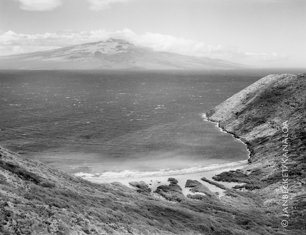 Kanapou Bay, 2017
1627 hits
Kanapou Bay faces Maui, across the Alalakeiki Channel. In Kanapou is the lua (pit, home) of the manō (shark) Kamōhoaliʻi, brother of Pele. A stone on the ahu at the summit of Moaʻula Nui, above, honors Kamōhoaliʻi. The lele at Moaʻula Iki. In the distance lies the island of Lānaʻi.") 17-9 MoaulaIki
17-9 MoaulaIki
1415 hits
The lele at Moaʻula Iki. In the distance lies the island of Lānaʻi. The ahu (stone altar) at Moa’ula Nui, a modern structure with double upright stones, to honor both...") 17-9 MoaulaNui
17-9 MoaulaNui
1524 hits
The ahu (stone altar) at Moa’ula Nui, a modern structure with double upright stones, to honor both the Nāulu rains and Kamōhoali’i, whose house lies below in Kanapou Bay. This ancient wiliwili tree is a remnant of the vast dryland native forest that once covered the isla...") 17-9 Wiliwili
17-9 Wiliwili
1428 hits
This ancient wiliwili tree is a remnant of the vast dryland native forest that once covered the island. It lies along the road near the summit of the island.