Choose filters
Cancel
Validate
Choose filters
Validate
Validate
Validate

 Erosion control efforts above Hakioawa, 2012") Erosion control efforts above Hakioawa, 2012
Erosion control efforts above Hakioawa, 2012
3695 hits
Erosion control efforts above Hakioawa, 2012 Perhaps related to this or nearby structures: \" ... Thus 'Ai'ai performed his good work in establish...") Hakioawa - Heiau, 2012
Hakioawa - Heiau, 2012
3206 hits
Perhaps related to this or nearby structures: " ... Thus 'Ai'ai performed his good work in establishing kū'ula and ko'a all around the island of Maui. He is also said to have visited Kaho'olawe and established a kū'ula at Hakioawa ... though it differs from the others in being built on a high bluff overlooking the sea, somewhat like a temple; its stones are in the form of a square, with a space in the middle where the fishermen of Kaho'olawe laid their first fish caught ... 'Awa and kapa were also placed there as offerings to the fishing 'aumakua." - from a translated mo'olelo in Hawaiian Fishing Legends, ed by Dennis Kawaharada, p. 19. The naulu rain clouds approach from Haleakalā. Because the island sits in the leeward rain shadow o...") Hakioawa - Pōhaku near kūʻula, 2012
Hakioawa - Pōhaku near kūʻula, 2012
2998 hits
The naulu rain clouds approach from Haleakalā. Because the island sits in the leeward rain shadow of Haleakalā, the naulu rain has a great deal of cultural significance on Kahoʻolawe. 1994. Ordnance projectiles gathered along the side of the dirt road at Kealialalo, part of the UXO c...") UXO at Kahoʻolawe, 1994
UXO at Kahoʻolawe, 1994
3396 hits
1994. Ordnance projectiles gathered along the side of the dirt road at Kealialalo, part of the UXO clearance prior to the island being returned to the State of Hawaiʻi. Much UXO remains, however. 1994 (3118 visits) On the east side of Hakioawa") Hakioawa - Kūʻula kai (fishing shrine) 1994
Hakioawa - Kūʻula kai (fishing shrine) 1994
3118 hits
On the east side of Hakioawa") 94 KuʻulaKai3
94 KuʻulaKai3
2973 hits A kūʻula at Hakioawa, on the east bluff overlooking the bay") Hakioawa - Kūʻula kai, 1994
Hakioawa - Kūʻula kai, 1994
3170 hits
A kūʻula at Hakioawa, on the east bluff overlooking the bay Prominent pohaku near the ku'ula (fishing shrine) on the east bluff overlooking Hakioawa") Hakioawa - Pōhaku near kūʻula kai, fishing shrine, 2012
Hakioawa - Pōhaku near kūʻula kai, fishing shrine, 2012
3131 hits
Prominent pohaku near the ku'ula (fishing shrine) on the east bluff overlooking Hakioawa A modern structure on the west side of Hakioawa - where awa ceremonies take place and where visitors...") Hakioawa - Kahua Lele, 2012
Hakioawa - Kahua Lele, 2012
3349 hits
A modern structure on the west side of Hakioawa - where awa ceremonies take place and where visitors chant at the rising of the sun. A structure marking the navigation pathway to Kahiki (foreign lands) at Kealaikahiki.") Heiau at Lae Kealaikahiki, 2015
Heiau at Lae Kealaikahiki, 2015
3414 hits
A structure marking the navigation pathway to Kahiki (foreign lands) at Kealaikahiki. Its name translates as \"the path to far lands.\" The traditional departure place for voyages to the s...") Lae Kealaikahiki, 2015
Lae Kealaikahiki, 2015
3773 hits
Its name translates as "the path to far lands." The traditional departure place for voyages to the south. Modern sailors confirm that winds and currents make this an ideal point of departure, cutting the transit time as much as 10 days. According to some accounts, the prominent line of pōhaku that used to extend out into the sea were used as target practice and destroyed by the US Navy. Four large pōhaku mark the cardinal points of the compass at Lae Kealaikahiki.") Lae Kealaikahiki, 2015
Lae Kealaikahiki, 2015
3391 hits
Four large pōhaku mark the cardinal points of the compass at Lae Kealaikahiki. A small upright and ahu lies to the left of the trail as one ascents Moaʻula Iki") Upright, Moaʻula Iki. 2015
Upright, Moaʻula Iki. 2015
2699 hits
A small upright and ahu lies to the left of the trail as one ascents Moaʻula Iki at Moaʻula Iki, 2015 (2670 visits) The lele (altar) at Moaʻula Iki.") The lele (altar) at Moaʻula Iki, 2015
The lele (altar) at Moaʻula Iki, 2015
2670 hits
The lele (altar) at Moaʻula Iki. The island was a naval bombing range for decades after WWII. Bombs like this can work their way to t...") Ordnance at Kahoʻolawe, 2015
Ordnance at Kahoʻolawe, 2015
3068 hits
The island was a naval bombing range for decades after WWII. Bombs like this can work their way to the surface, even in places scanned and cleared of UXO (unexploded ordnance). Strands of Paʻuohiʻiaka thrive below a clump of pili on the hardpan. All replanting in the upland ...") Paʻuohiʻiaka
Paʻuohiʻiaka
2644 hits
Strands of Paʻuohiʻiaka thrive below a clump of pili on the hardpan. All replanting in the upland region must be done above ground because of the danger of UXO (unexploded ordance) just below the surface.") 15 4 Replanting2
15 4 Replanting2
2622 hits A double upright (rare) at the adz quarry") Puʻu Moiwi adz quarry, 1994
Puʻu Moiwi adz quarry, 1994
3326 hits
A double upright (rare) at the adz quarry The double upright (rare) at the adz quarry") Puʻu Moiwi adz quarry, 1994
Puʻu Moiwi adz quarry, 1994
3443 hits
The double upright (rare) at the adz quarry This lies along the trail to the summit, on the right as one ascends. A very large, very flat pōhak...") Double upright, Moaʻula Iki, 2015
Double upright, Moaʻula Iki, 2015
2205 hits
This lies along the trail to the summit, on the right as one ascends. A very large, very flat pōhaku lies just below, out of sight. Small stone ʻiliʻili fills the gap between the two uprights. It is possible that there is a deliberate astronomical alignment created by the two uprights. Thousands of posts like this mark the limit of sub-surface ordnance clearance. Beyond the posts, onl...") A post marking the limit of UXO sub-surface clearance, 2015
A post marking the limit of UXO sub-surface clearance, 2015
2484 hits
Thousands of posts like this mark the limit of sub-surface ordnance clearance. Beyond the posts, only the surface has been cleared of UXO (unexploded ordnance). Volunteers planting natives in the hardpan. Because it has not been cleared for UXO below the surfac...") Kanu uka, 2015
Kanu uka, 2015
2117 hits
Volunteers planting natives in the hardpan. Because it has not been cleared for UXO below the surface, all planting here must take place above the ground. Haleakalā is in the distance. Its name translates as \"the path to far lands.\" The traditional departure place for voyages to the s...") Lae Kealaikahiki, 2015
Lae Kealaikahiki, 2015
2217 hits
Its name translates as "the path to far lands." The traditional departure place for voyages to the south. Modern sailors confirm that winds and currents make this an ideal place for departure. According to some accounts, the prominent line of pōhaku that used to extend out into the sea were used as target practice and destroyed by the US Navy. Planting ʻakiʻaki grass to control beach erosion at Hanakanaia Bay") Kanu kahakai, 2015
Kanu kahakai, 2015
2375 hits
Planting ʻakiʻaki grass to control beach erosion at Hanakanaia Bay Volunteers planting natives in the hardpan. Because it has not been cleared for UXO below the surfac...") Kanu uka, 2015
Kanu uka, 2015
2037 hits
Volunteers planting natives in the hardpan. Because it has not been cleared for UXO below the surface, all planting here must take place above the ground. Haleakalā is in the distance. All replanting in the upland region must be done above ground because of the danger of UXO (unexplod...") Irrigated planting beds on the hardpan
Irrigated planting beds on the hardpan
2231 hits
All replanting in the upland region must be done above ground because of the danger of UXO (unexploded ordnance) just below the surface. Native vegetation planted in erosion gullies. Haleakalā lies in the distance.") Native plants thriving in erosion gullies on the hardpan
Native plants thriving in erosion gullies on the hardpan
2156 hits
Native vegetation planted in erosion gullies. Haleakalā lies in the distance. Planting ʻakiʻaki grass to control beach erosion at Hanakanaia Bay") Kanu kahakai, 2015
Kanu kahakai, 2015
2847 hits
Planting ʻakiʻaki grass to control beach erosion at Hanakanaia Bay Planting ʻakiʻaki grass to control beach erosion at Hanakanaia Bay") Kanu kahakai, 2015
Kanu kahakai, 2015
2238 hits
Planting ʻakiʻaki grass to control beach erosion at Hanakanaia Bay Planting ʻakiʻaki grass to control beach erosion at Hanakanaia Bay") Kanu kahakai, 2015
Kanu kahakai, 2015
2128 hits
Planting ʻakiʻaki grass to control beach erosion at Hanakanaia Bay") 15 12 Kanu9
15 12 Kanu9
2022 hits (2150 visits) Volunteers work to clear the Ala Loa. The project was begun by the PKO to create a path that circles...") Ala Loa (Long Path)
Ala Loa (Long Path)
2150 hits
Volunteers work to clear the Ala Loa. The project was begun by the PKO to create a path that circles the island, to be used for traditional protocol during the yearly Makahiki. As part of the traditional protocol, the god Lono is carried in procession entirely around an island. (2075 visits) Volunteers work to clear the Ala Loa. The project was begun by the PKO to create a path that circles...") Ala Loa (Long Path)
Ala Loa (Long Path)
2075 hits
Volunteers work to clear the Ala Loa. The project was begun by the PKO to create a path that circles the island, to be used for traditional protocol during the yearly Makahiki. As part of the traditional protocol, the god Lono is carried in procession entirely around an island. (2056 visits) Volunteers work to clear the Ala Loa. The project was begun by the PKO to create a path that circles...") Ala Loa (Long Path)
Ala Loa (Long Path)
2056 hits
Volunteers work to clear the Ala Loa. The project was begun by the PKO to create a path that circles the island, to be used for traditional protocol during the yearly Makahiki. As part of the traditional protocol, the god Lono is carried in procession entirely around an island.") 16 4 AlaLoa-12
16 4 AlaLoa-12
1985 hits (1961 visits)") Ala Loa (Long Path)
Ala Loa (Long Path)
1961 hits This is a modern structure intended to serve as a teaching center for navigators. It was built under...") Heiau at Kealaikahiki
Heiau at Kealaikahiki
2139 hits
This is a modern structure intended to serve as a teaching center for navigators. It was built under the direction of Mau Pilug, the navigator credited with reviving traditional Polynesian navigation. Moaʻula Iki - sunrise - after the protocol") Moaʻula Iki - sunrise, 2016
Moaʻula Iki - sunrise, 2016
2058 hits
Moaʻula Iki - sunrise - after the protocol") 16 3 Kanu-1
16 3 Kanu-1
1912 hits Just after the chanting of E Ala E, when the sun has risen and the protocol had ended - taken with t...") Moaʻula Iki - sunrise - after the protocol, 2016
Moaʻula Iki - sunrise - after the protocol, 2016
1900 hits
Just after the chanting of E Ala E, when the sun has risen and the protocol had ended - taken with the permission of the chanters, of course.") 16 3 Kanu-2
16 3 Kanu-2
1991 hits Between the stakes lies the section cleared of UXO (unexploded ordnance) down to a depth of four fee...") UXO markers, Kahoʻolawe, 2016
UXO markers, Kahoʻolawe, 2016
2550 hits
Between the stakes lies the section cleared of UXO (unexploded ordnance) down to a depth of four feet. Outside the markers, the terrain has only been surface (visually) cleared. Other sections of the island in more inaccessible terrain have never been cleared and are off limits. This prominent upright lies close to the platform shown in another image in this album. The upright ...") Upright pōhaku, Hanakanaia, 2016
Upright pōhaku, Hanakanaia, 2016
1835 hits
This prominent upright lies close to the platform shown in another image in this album. The upright forms a potentially intriguing alignment with the large stone at the nearby ahu. Highly endangered ʻilioholoikauaua (Monk Seals) sometimes rest on the beach. This prominent upright lies close to the platform shown in another image in this album. The upright ...") Upright pōhaku, Hanakanaia, 2016
Upright pōhaku, Hanakanaia, 2016
1945 hits
This prominent upright lies close to the platform shown in another image in this album. The upright forms a potentially intriguing alignment with the large stone at the nearby ahu. The post warns of the limit of clearance for sub-surface UXO (unexploded ordnance). This platform lies next to a large pōhaku with a deep cavity at its base. Branch coral makes up a p...") Large Ahu, Hanakanaia, 2016
Large Ahu, Hanakanaia, 2016
1952 hits
This platform lies next to a large pōhaku with a deep cavity at its base. Branch coral makes up a part of its structure, and a prominent upright stone stands nearby, next to the sandy beach. Members of a well-known Hawaiian family identify this structure as connected with Kanaloa. (2080 visits) Volunteers work to clear the Ala Loa. The project was begun by the PKO to create a path that circles...") Ala Loa (Long Path)
Ala Loa (Long Path)
2080 hits
Volunteers work to clear the Ala Loa. The project was begun by the PKO to create a path that circles the island, to be used for traditional protocol during the yearly Makahiki. As part of the traditional protocol, the god Lono is carried in procession entirely around an island. All replanting in the upland region must be done above ground because of the danger of UXO (unexplod...") Irrigated planting beds on the hardpan
Irrigated planting beds on the hardpan
1913 hits
All replanting in the upland region must be done above ground because of the danger of UXO (unexploded ordnance) just below the surface. Haleakalā and Maui are in the distance.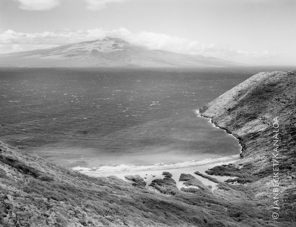 Kanapou Bay, 2017
1664 hits
Kanapou Bay faces Maui, across the Alalakeiki Channel. In Kanapou is the lua (pit, home) of the manō (shark) Kamōhoaliʻi, brother of Pele. A stone on the ahu at the summit of Moaʻula Nui, above, honors Kamōhoaliʻi. The lele at Moaʻula Iki. In the distance lies the island of Lānaʻi.") 17-9 MoaulaIki
17-9 MoaulaIki
1453 hits
The lele at Moaʻula Iki. In the distance lies the island of Lānaʻi. The ahu (stone altar) at Moa’ula Nui, a modern structure with double upright stones, to honor both...") 17-9 MoaulaNui
17-9 MoaulaNui
1561 hits
The ahu (stone altar) at Moa’ula Nui, a modern structure with double upright stones, to honor both the Nāulu rains and Kamōhoali’i, whose house lies below in Kanapou Bay.