2003
2004
2005
2006
2007
2008
2009
2010
2011
2012
2013
2014
2015
2016
2017
2018
2019
2020
2021
2022
2023
All

") Kaniakapūpū, 2017
Kaniakapūpū, 2017
633 hits") Kaniakapūpū, 2017
Kaniakapūpū, 2017
707 hits The boulders form a shallow cavity or sheltered area. The site lies in a complex, just downhill fro...") Small enclosure against boulders, Waikīkī Ahupuaʻa, 2020
Small enclosure against boulders, Waikīkī Ahupuaʻa, 2020
595 hits
The boulders form a shallow cavity or sheltered area. The site lies in a complex, just downhill from a medium-sized heiau. The highest heiau on Oʻahu and one of only two dedicated to the sun. The other was at Kapiolani Par...") Mokaʻena Marae, Kuaokalā, 2003
Mokaʻena Marae, Kuaokalā, 2003
213 hits
The highest heiau on Oʻahu and one of only two dedicated to the sun. The other was at Kapiolani Park bandstand. This modern ahu was built to mark the approximate place where a fishing shrine was used by local fam...") Ahu kahakai, Mākua, 2019
Ahu kahakai, Mākua, 2019
769 hits
This modern ahu was built to mark the approximate place where a fishing shrine was used by local families until WWII. The shrine was destroyed by the Army. at a spot where turtles come to feed, 2019 (188 visits)") Honu (turtles) at a spot where turtles come to feed, 2019
Honu (turtles) at a spot where turtles come to feed, 2019
188 hits A two-tiered structure in excellent condition") Kapaʻa, 2018
Kapaʻa, 2018
1146 hits
A two-tiered structure in excellent condition The residence of Lonoikamakahiki at Paniau, according to the Kekahuna map. Now, the location of the ...") Paniau, 2018
Paniau, 2018
1085 hits
The residence of Lonoikamakahiki at Paniau, according to the Kekahuna map. Now, the location of the Keauhou Surf and Racket Club. Hale Aʻama Heiau at the Keolanhihi complex, according to the Kekahuma map, which identifies it as a...") Haleaʻama Heiau, 2018
Haleaʻama Heiau, 2018
1120 hits
Hale Aʻama Heiau at the Keolanhihi complex, according to the Kekahuma map, which identifies it as a surfing heiau. Nobody now surfs in that area; it is possible that wave patterns have shifted. Or perhaps its connection with surfing is ceremonial and indirect.") Kuʻemanu Heiau, 2018
Kuʻemanu Heiau, 2018
1097 hits This image was made from the top of the holua. The end closest to the highway is overgrown.") Holualoa, 2018
Holualoa, 2018
1020 hits
This image was made from the top of the holua. The end closest to the highway is overgrown. A large structure near Lekeke, possibly a heiau.") Lekeke, 2018
Lekeke, 2018
1103 hits
A large structure near Lekeke, possibly a heiau. A platform in a petroglyph field at the Kona - Kohala border, along the Old Government Road") Ahu o Lono, 2018
Ahu o Lono, 2018
1067 hits
A platform in a petroglyph field at the Kona - Kohala border, along the Old Government Road") Kukuipahu, 2018
Kukuipahu, 2018
1049 hits A two-tiered structure in excellent condition.") Kapaʻa, 2018
Kapaʻa, 2018
1158 hits
A two-tiered structure in excellent condition. A coastal heiau with a rather jumbled exterior but with a beautiful interior platform paved with ʻi...") Waiakalilo, 2018
Waiakalilo, 2018
1046 hits
A coastal heiau with a rather jumbled exterior but with a beautiful interior platform paved with ʻiliʻili. Note the small alcove on the right paved with slightly larger water-worn stones. The road was built in the 19th century, probably by prison labor. Public access along the road is st...") Old government road
Old government road
1064 hits
The road was built in the 19th century, probably by prison labor. Public access along the road is still protected by law. Possibly a house platform") Kakapa Bay, 2018
Kakapa Bay, 2018
1077 hits
Possibly a house platform A possible ceremonial platform adjacent to the ocean.") Kakapa Bay, 2018
Kakapa Bay, 2018
1038 hits
A possible ceremonial platform adjacent to the ocean. The large structure adjacent to the fishtrap at ʻAiʻōpio. Signs at this heiau mistakenly identifi...") Puʻuoina Heiau, 2018
Puʻuoina Heiau, 2018
1088 hits
The large structure adjacent to the fishtrap at ʻAiʻōpio. Signs at this heiau mistakenly identified it several years ago as Halemanō Heiau, which may lie under water outside of the entrance to Honokōhau Harbor. Along Aliʻi Rd.") Laʻaloa Heiau, 2018
Laʻaloa Heiau, 2018
1077 hits
Along Aliʻi Rd. Both heiau have been reconstructed") Keʻekū Heiau and Hāpaialiʻi Heiau, 2018
Keʻekū Heiau and Hāpaialiʻi Heiau, 2018
975 hits
Both heiau have been reconstructed") Holualoa, 2018
Holualoa, 2018
1074 hits Near the pā of Kalaniopuʻu") Hōkūliʻa 16756, 2018
Hōkūliʻa 16756, 2018
950 hits
Near the pā of Kalaniopuʻu Near the pā (house enclosure) of Kalaniopuʻu, Aliʻi Nui at the time of Cookʻs visit.") Hōkūliʻa 16756, 2018
Hōkūliʻa 16756, 2018
991 hits
Near the pā (house enclosure) of Kalaniopuʻu, Aliʻi Nui at the time of Cookʻs visit. In the distance is Puʻu Oahu.") Hōkūliʻa 16745, 2018
Hōkūliʻa 16745, 2018
738 hits
In the distance is Puʻu Oahu. A small platform at the shore near the pā of Kalaniopuʻu") Hōkūliʻa 16758, 2018
Hōkūliʻa 16758, 2018
1017 hits
A small platform at the shore near the pā of Kalaniopuʻu The stepped structure at the entrance to the cave. Note the kiʻi pōhaku (petroglyphs) on the left ...") Hōkūliʻa Halekiʻi, 2018
Hōkūliʻa Halekiʻi, 2018
978 hits
The stepped structure at the entrance to the cave. Note the kiʻi pōhaku (petroglyphs) on the left rock face. In the distance is Kealakekua Bay") Location of the battle of Moku Ohai
Location of the battle of Moku Ohai
1156 hits
In the distance is Kealakekua Bay Remains of the holua (sledding run). Houses below appear to have used its stones for wall building.") Puʻu Pāheʻeheʻe Holua, 2018
Puʻu Pāheʻeheʻe Holua, 2018
184 hits
Remains of the holua (sledding run). Houses below appear to have used its stones for wall building. Perhaps the lower terraces of Pāheʻeheʻe heiau") Puʻu Pāheʻeheʻe, 2018
Puʻu Pāheʻeheʻe, 2018
203 hits
Perhaps the lower terraces of Pāheʻeheʻe heiau Remains of the mauka terrace behind the plantationera cemetery") Pāheʻeheʻe Heiau, 2018
Pāheʻeheʻe Heiau, 2018
204 hits
Remains of the mauka terrace behind the plantationera cemetery Punamanō is a pond a little mauka from this pōhaku, but an elderly Kahuku resident heard stories a...") Punamanō, Kahuku, 2018
Punamanō, Kahuku, 2018
176 hits
Punamanō is a pond a little mauka from this pōhaku, but an elderly Kahuku resident heard stories as a child of an underground connection between the pond and pōhaku, and of a woman who used to make the passage. Waianaʻe residents with ancestral connections to that area use the term Unu rather than heiau to re...") Kamaile Unu, 1996
Kamaile Unu, 1996
1461 hits
Waianaʻe residents with ancestral connections to that area use the term Unu rather than heiau to refer to large ceremonial structures.") Kamaile Unu, 1996
Kamaile Unu, 1996
192 hits Several 500-ton blasts of TNT made this crater in 1965. It was an attempt by the US Navy to mimic th...") Kahoʻolawe, 2017
Kahoʻolawe, 2017
1935 hits
Several 500-ton blasts of TNT made this crater in 1965. It was an attempt by the US Navy to mimic the effects of a nuclear blast and to study its efffects on ships moored nearby. Water in the crater used to be brackish but is now entirely saline") 17-9 Luku3
17-9 Luku3
1365 hits Sheets wrapped around kiawe logs, an attempt to catch topsoil being blown away by the strong winds t...") Kahoʻolawe, 2017
Kahoʻolawe, 2017
1821 hits
Sheets wrapped around kiawe logs, an attempt to catch topsoil being blown away by the strong winds that sweep the upland. This dirt track allows access to sections of the hard pan being replanted with native vegetation. It...") Kahoʻolawe, 2017
Kahoʻolawe, 2017
1870 hits
This dirt track allows access to sections of the hard pan being replanted with native vegetation. It lies just above Hakioawa Bay. Between the posts, ground has been cleared for UXO down to a depth of four feet. This ancient wiliwili tree is a remnant of the vast dryland native forest that once covered the isla...") 17-9 Wiliwili
17-9 Wiliwili
1450 hits
This ancient wiliwili tree is a remnant of the vast dryland native forest that once covered the island. It lies along the road near the summit of the island.") 17-9 Kanu1
17-9 Kanu1
1350 hits The ahu (stone altar) at Moa’ula Nui, a modern structure with double upright stones, to honor both...") 17-9 MoaulaNui
17-9 MoaulaNui
1547 hits
The ahu (stone altar) at Moa’ula Nui, a modern structure with double upright stones, to honor both the Nāulu rains and Kamōhoali’i, whose house lies below in Kanapou Bay. The lele at Moaʻula Iki. In the distance lies the island of Lānaʻi.") 17-9 MoaulaIki
17-9 MoaulaIki
1439 hits
The lele at Moaʻula Iki. In the distance lies the island of Lānaʻi.") 17-9 ErodedGully
17-9 ErodedGully
1478 hits") 17-9 Kanu3
17-9 Kanu3
1595 hits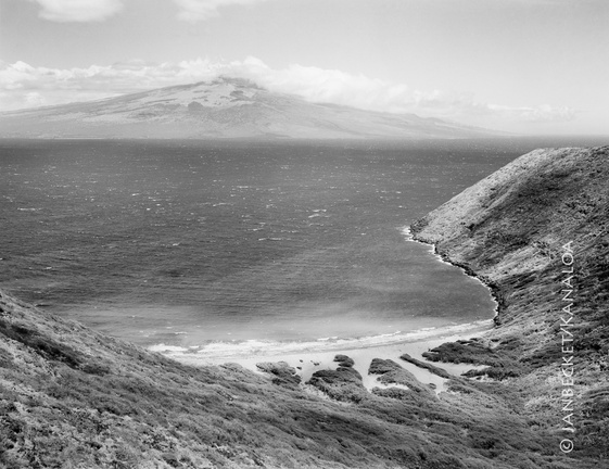 Kanapou Bay, 2017
1649 hits
Kanapou Bay faces Maui, across the Alalakeiki Channel. In Kanapou is the lua (pit, home) of the manō (shark) Kamōhoaliʻi, brother of Pele. A stone on the ahu at the summit of Moaʻula Nui, above, honors Kamōhoaliʻi. Local families relate that the corner stones of r Kawaihaʻo were quarried at this site.") Quarry marks, Keaʻau, 2017
Quarry marks, Keaʻau, 2017
219 hits
Local families relate that the corner stones of r Kawaihaʻo were quarried at this site., 2017 (210 visits)") Waiʻanae Kiʻi Pōhaku (petroglyph), 2017
Waiʻanae Kiʻi Pōhaku (petroglyph), 2017
210 hits A prominent upright stone sits on a platform overlooking the ocean.") Upright and platform, Mākua, 1996
Upright and platform, Mākua, 1996
650 hits
A prominent upright stone sits on a platform overlooking the ocean.") Upright at Mokaʻena Marae, Kuaokalā, 1993
Upright at Mokaʻena Marae, Kuaokalā, 1993
666 hits